Proposed Combwich to Hinkley Point Shared Use Cycle Path
The Hinkley Point C project is considering a proposal to develop a shared use cycle path running from the village of Combwich to Hinkley Point. It would provide a sustainable commuting route to Hinkley Point A, B and C power stations whilst also providing wider local value – offering an enjoyable route for leisure purposes. The new route would be entirely funded by the Hinkley Point C project and, for the majority of the route, would look to resurface existing paths.
The current proposal builds on existing cycle infrastructure in the area and also connects to the existing cycle route along the C182 from Combwich towards Cannington and Bridgwater.

As part of the application process, we are carrying out a public consultation to discuss the proposal and better understand the views of the local community and wider public. The views and ideas shared as part of the consultation will help shape and inform the next phase of the design process – including a full planning application.
The Project is classified as ‘development’ under Section 55(1) of the Town and County Planning Act, 1990 and therefore a full planning application would need to be made to both Sedgemoor District Council and Somerset West and Taunton Council as the relevant Local Planning Authorities for a route that covers both districts. As the area moves to a Unitary Authority, after April next year a single application would be made to the new Somerset Council. A full application would only be submitted following a full assessment of our consultation.
Our proposals for a new cycle path
The proposed shared user cycle route covers approximately 9.3 km and follows an existing rural highway and Public Rights of Way. It would begin just north of the village of Combwich and end at the northern perimeter of the Hinkley Point complex.
It represents a diverse route, proposed to cross agricultural and coastal land with a variety of existing rural land uses including a bridleway, a section of rural highway, Common Land, the England Coast Path National Trail, and the northern perimeter of the Hinkley Point complex which includes a short section of woodland.


For the majority of the route, the intention is to provide a new surface to existing footpaths. These footpaths would need to be upgraded to a bridleway to allow use by a wide variety of non-motorised users including cyclists, horse riders, pedestrians and those with limited mobility. In addition to the change to bridleways, there are some parts of the proposed route which are not currently designated as rights of way at all, they would have to be designated as such to allow the development.
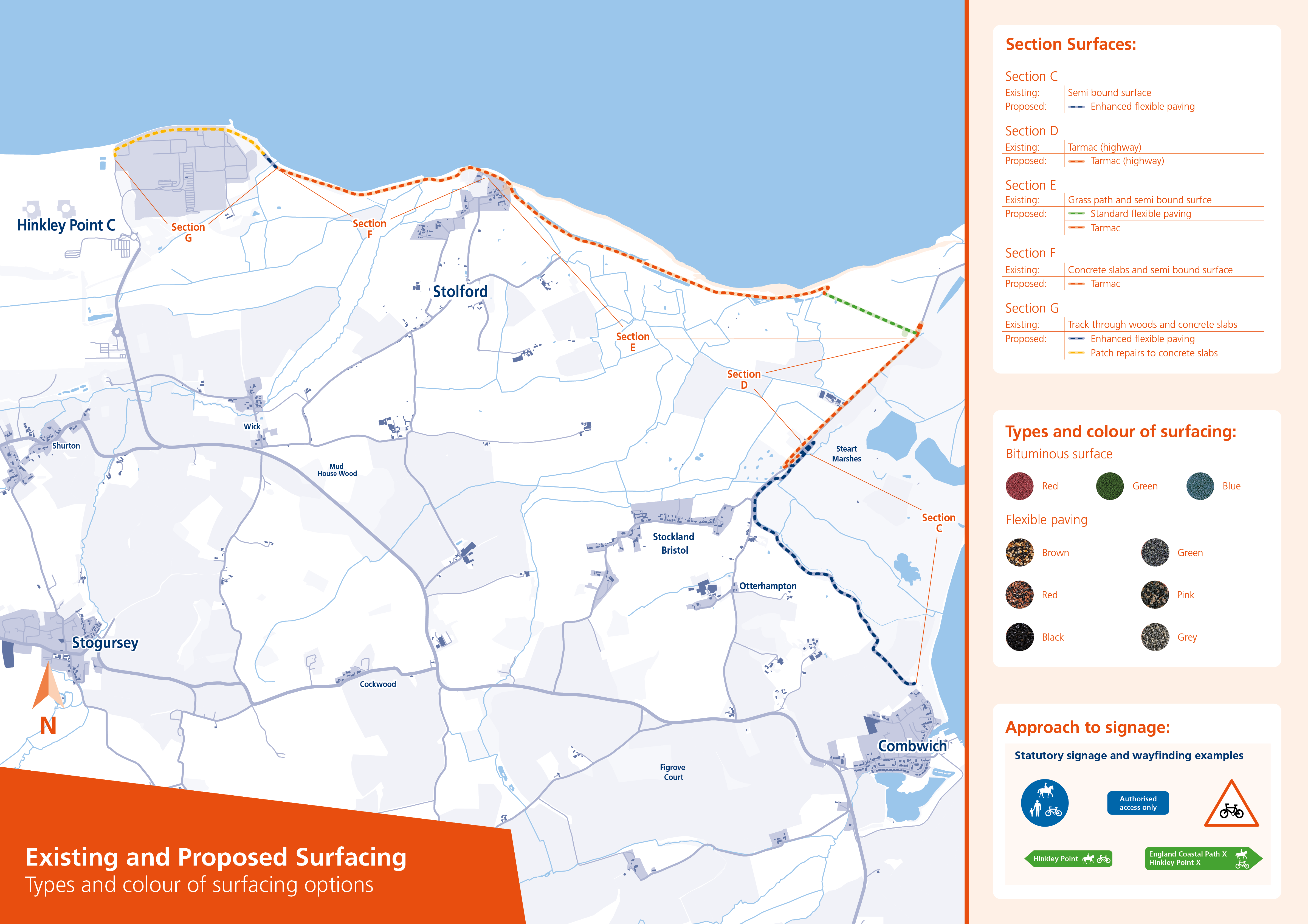
An important part of this consultation is to seek views on the most suitable surface for the proposal with a range of options to be considered. At the moment, the current route has a variety of different surfaces including concrete, grass and porous material. The surfacing for the route will need to be fit for purpose for many potential users including cyclists, horse riders, pedestrians and those with limited mobility. In addition, some landowners and organisations accessing and maintaining land may need to use the route as a means of access. We are seeking views on the most appropriate surfacing for the path including flexible paving which is made from recycled tyres and Asphalt.
Proposed Route Overview

The route in detail
The proposed route is divided into 5 areas; Areas C – G covering approximately 9.3km and 11.2ha of land area as detailed in the overview plan.
The majority of the proposed route follows an existing rural highway and Public Right of Way. A small section of the proposed route will need to be created where no right of way exists at the moment. In addition, all of the proposed route would need to be designated as a Bridleway before it could be used by cyclists and horse riders. The approximate lengths of each route section would be as follows;
Environment Agency Bridleway to Stert Drove (Section C)
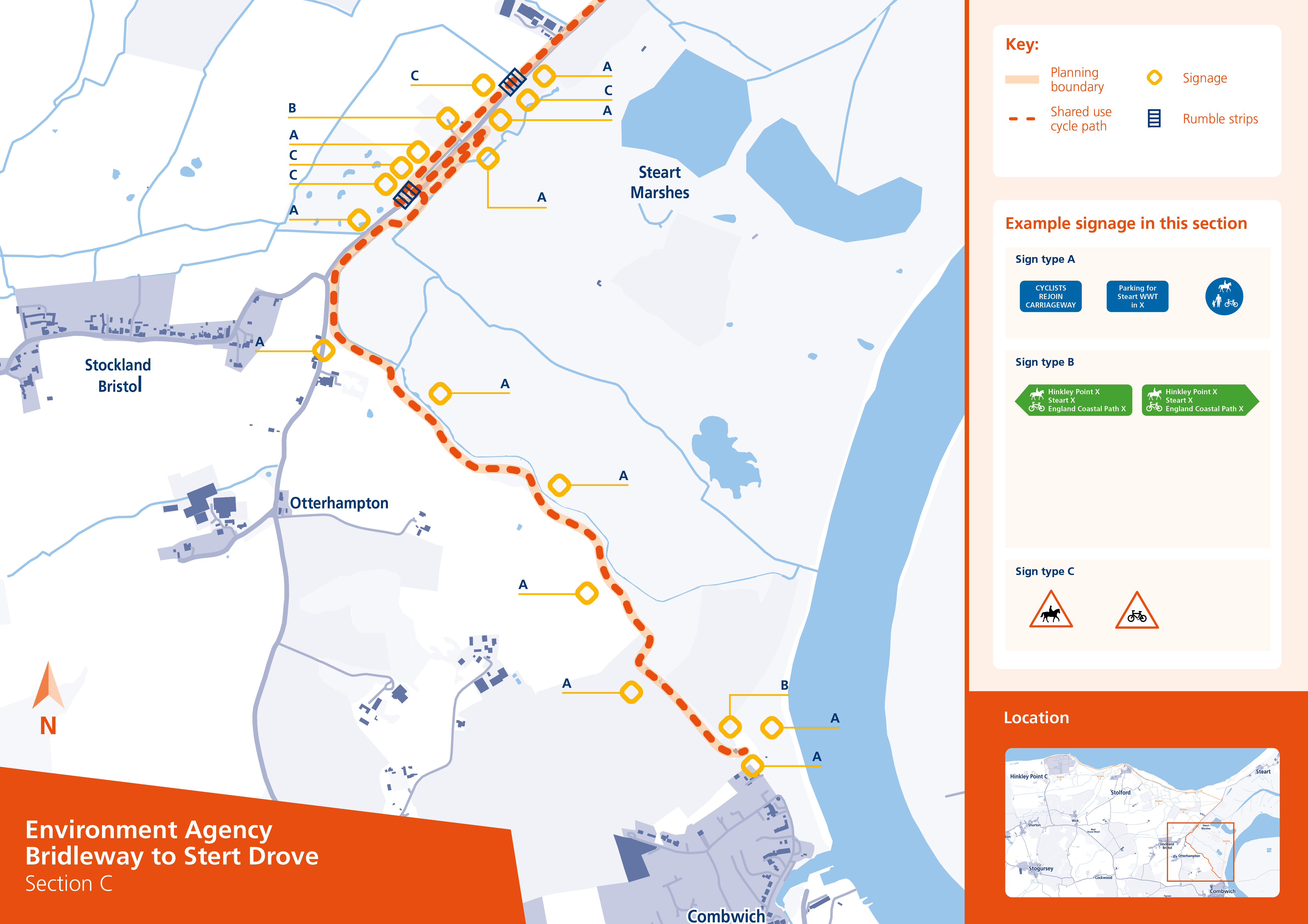
Environment Agency Bridleway to Stert Drove (Section C)
2.3km
Stert Drove (Section D)
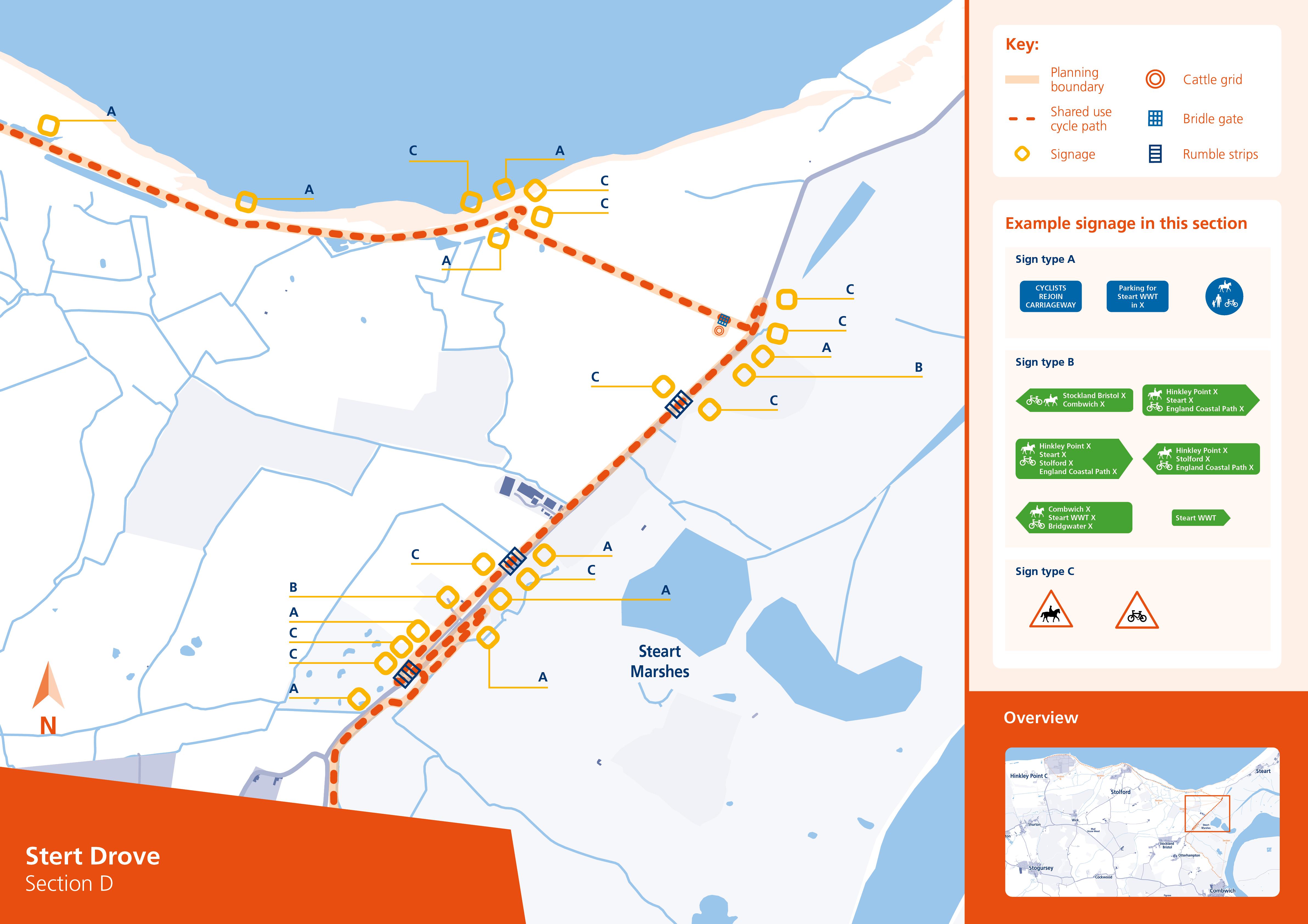
Stert Drove (Section D)
1.08 km
Stert Drove to Gorpit Lane Car Park (Section E)
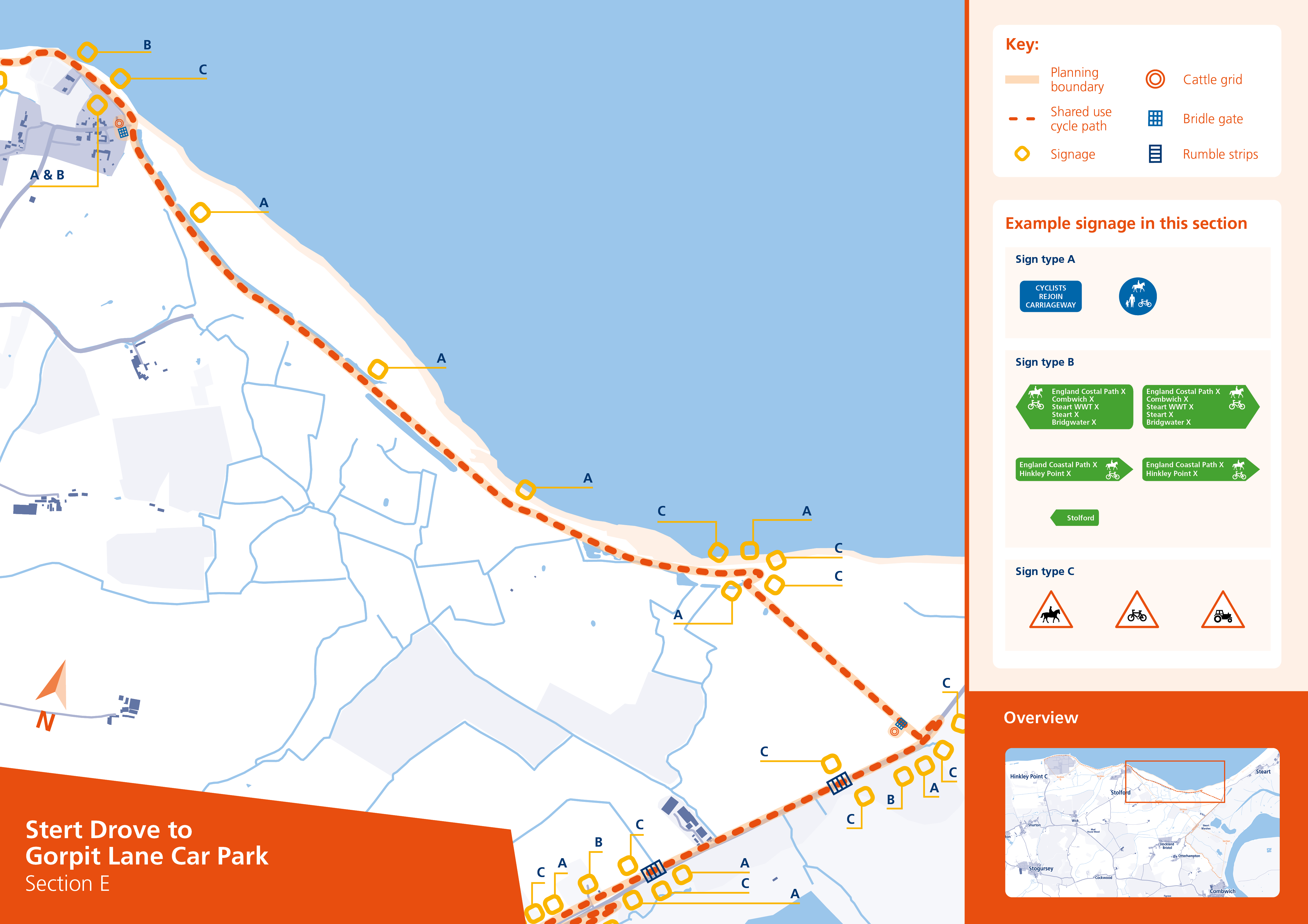
Stert Drove to Gorpit Lane Car Park (Section E)
2.96 km
Gorpit Lane Carpark to the approach to Hinkley Point Complex (Section F)
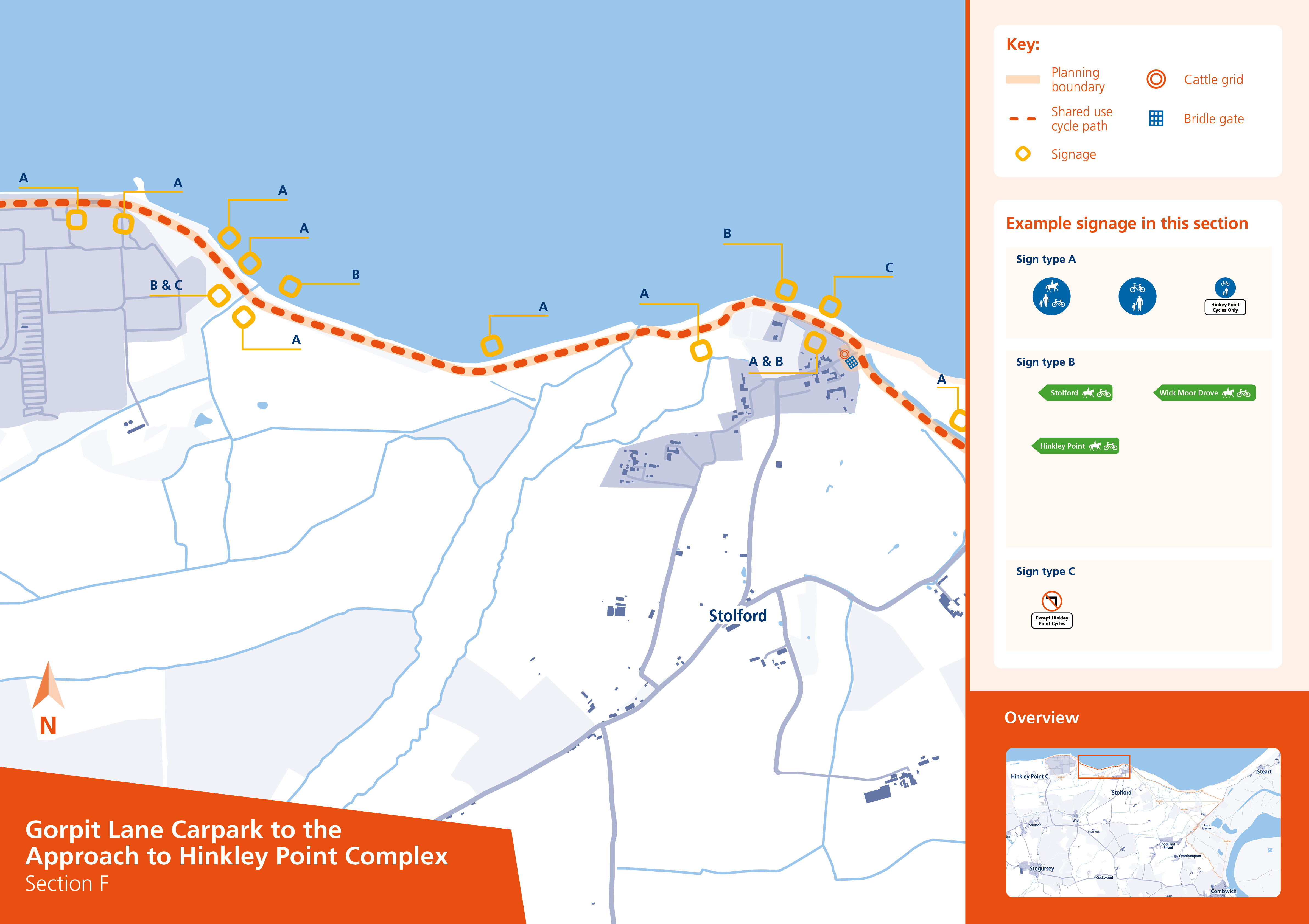
Gorpit Lane Carpark to the approach to Hinkley Point Complex (Section F)
1.70 km
Hinkley Point Northern Perimeter (Section G)
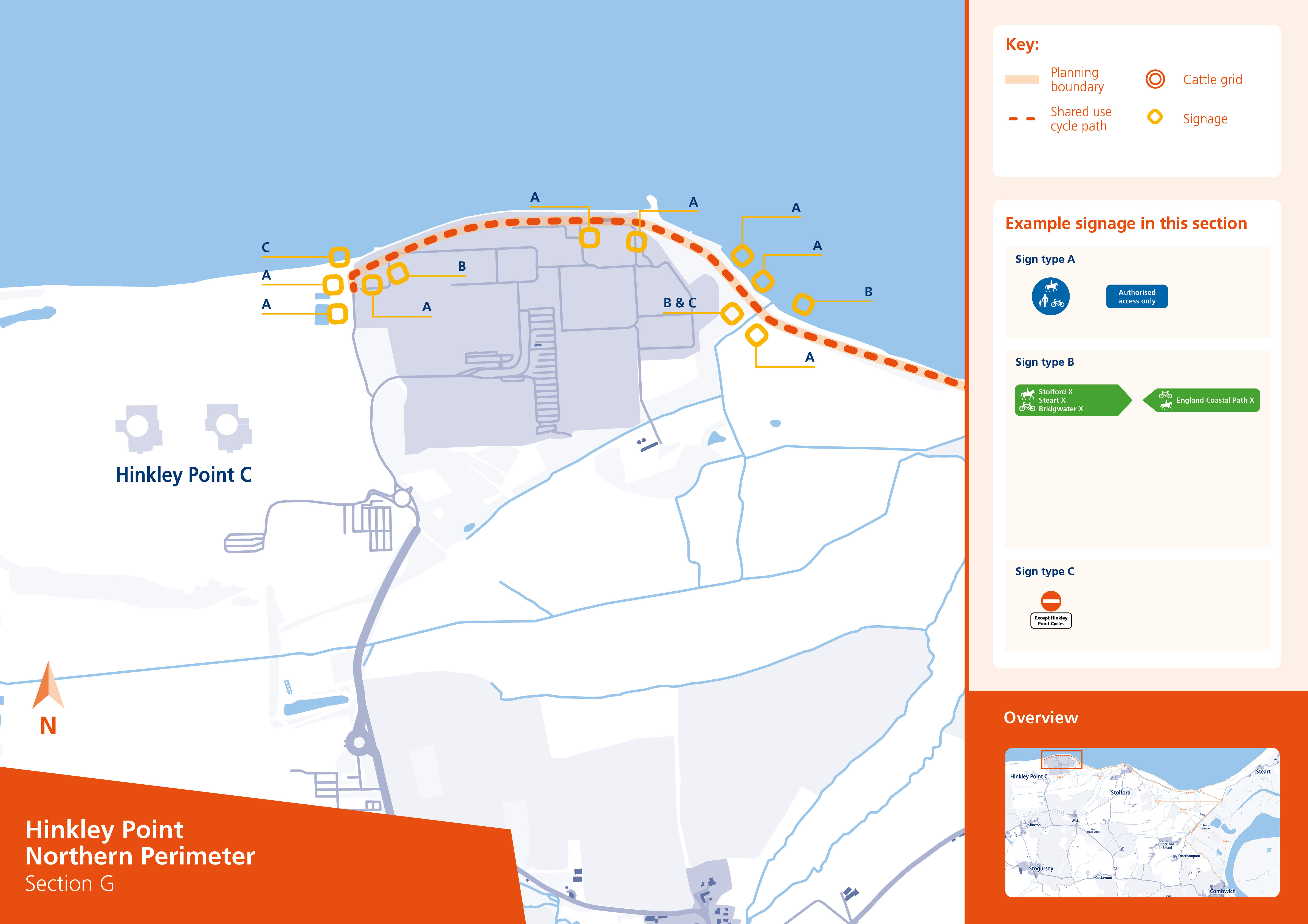
Hinkley Point Northern Perimeter (Section G)
1.25 km
Existing and proposed surfaces
Cattle grids- alternative locations
Parts of the proposed route (Sections E, F and part of G) follow what is currently a public footpath along the coast. In order for these areas to be used by cyclists, a Bridleway Creation Order (BCO) has been submitted to Somerset County Council to remove the footpath designation and create a bridleway which, alongside providing equestrian use, will help facilitate the proposed cycle path.
This Order also covers areas outside of the proposed scheme and does not cover Section G which is on land owned by EDF Energy and the Nuclear Decommissioning Authority as part of the Hinkley Point complex. The proposed route through Section G will also need to have permissive cycle route status for use only by cyclists commuting to Hinkley Point.
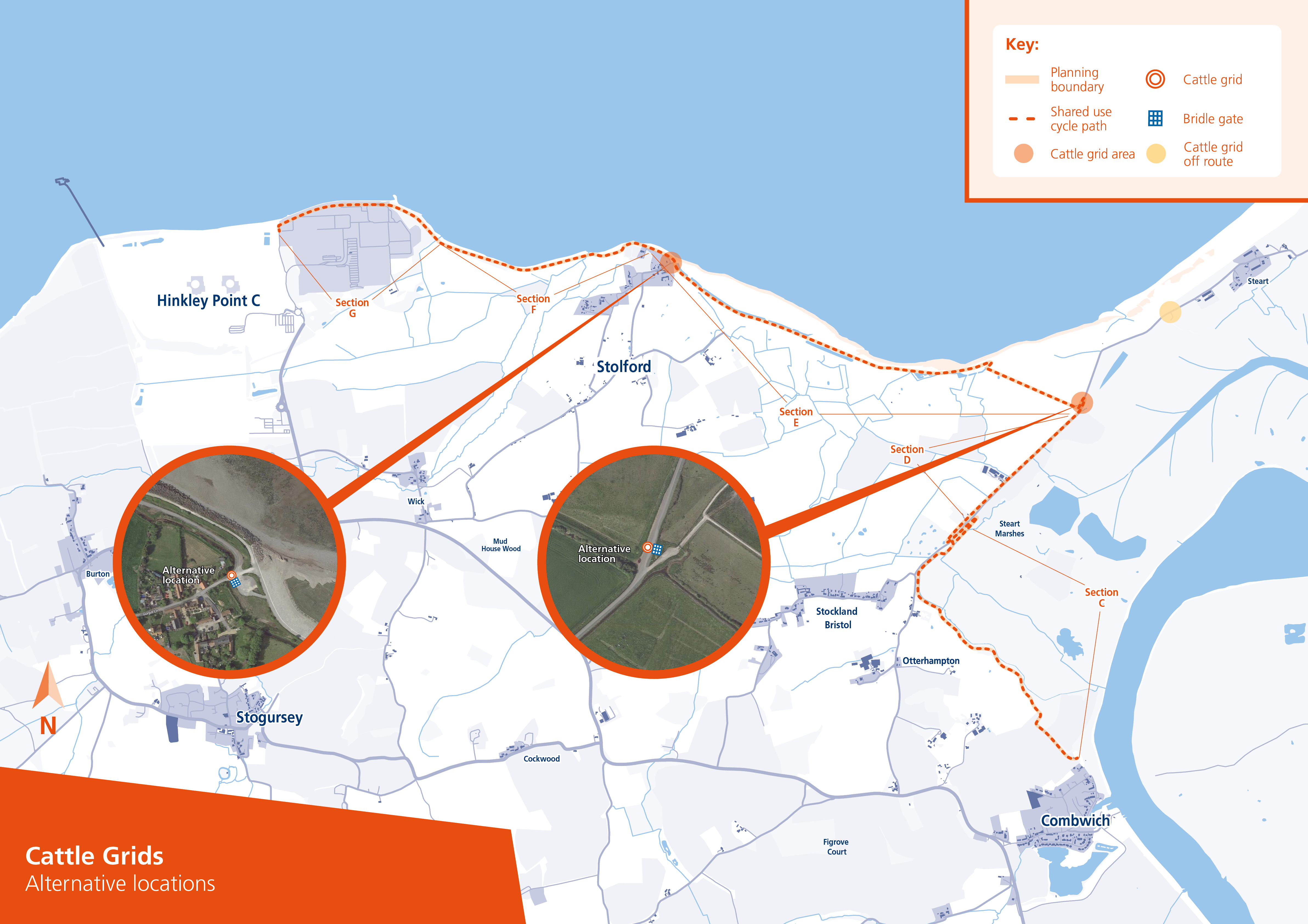
The proposed works along the route are small scale with limited development and are of a minimally invasive nature. The proposed works include minor surfacing, minimal widening in certain areas, signage and wayfinding, and the creation of two cattle grids with bridle gates alongside (one cattle grid is on the route at the junction of Section D and E and the other is just off the route at Stolford). A third cattle grid is proposed to be provided by Somerset County Council to the Northeast of Steart, outside of the red line boundary of the proposal, therefore the design of this cattle grid is not included in this proposal.

Previous Proposals
In 2013 we produced an initial feasibility into a route running from Cannington to Hinkley Point. Nine route options were identified and considered against their individual strengths, weaknesses and overall deliverability. Following the initial feasibility review, it was decided to split the route into two sections. Section 1 could run between Cannington and Combwich with Section 2 running between Combwich and Hinkley Point.
Engagement with landowners took place during November 2014 and indicated that a number would be unwilling to enter into discussions for a cycle route to pass some areas of their land. Potential mitigation measures were suggested but felt not acceptable by the landowners. As a result, proposals are now focussing on the second section, that could run out towards Stert Drove and along the existing coastal path towards Hinkley Point.
Getting involved in the consultation
Our consultation is designed to share the proposed route with all interested parties. The opinions, comments, thoughts and ideas from this exercise will help shape and inform the next stage of this project.
Two public consultation events are being held in separate locations to cover the two key local communities on the proposed route.
27th September 2022, Otterhampton Village Hall, 1pm - 8pm
6th October 2022, Stogursey Victory Hall, 3pm - 7pm
As these are drop in events, visitors are welcome to join at any point throughout the opening times.
The deadline for submitting your comments is Monday 31st October
Having considered the information here, you can also leave your feedback by completing the questionnaire below:
Frequently Asked Questions
Why is Hinkley Point C proposing this scheme
This scheme is being proposed primarily to provide an alternative cycle route for people commuting between Combwich and the Hinkley Point area who currently would have to use the C182. The new shared use cycle path would also complete a wider off main-road cycle route between Bridgwater and Hinkley Point. The scheme could also provide wider local value – offering an enjoyable route for leisure purposes.
What benefits will the scheme have for the local community?
In addition to a sustainable commuting route for those working at Hinkey Point in the longer term, the scheme would also offer an enjoyable route for leisure purposes and improved access to the outdoors for those people with mobility challenges. The benefits of activity and exercise are well understood and so the increased access could well help to improve the health and wellbeing of local communities.
How will the scheme be funded?
If taken forward, the scheme would be entirely funded by Hinkley Point C.
How long will the scheme take to construct?
Depending on the type of surfacing proposed, the route would take around 12 months to construct.
What surfacing is proposed?
A key part of this consultation is to seek input on the type of surfacing that could be used on the proposed route. At the moment the route has a variety of different surfaces including concrete, grass and porous material. The surfacing for the route will need to be fit for purpose for many potential users including cyclists, horse riders, pedestrians and those with limited mobility. In addition, some landowners and organisations accessing and maintaining land may need to use the route as a means of access. We are seeking views on the most appropriate surfacing for the path including Flexible paving (made from recycled tyres) and Asphalt.
When could the scheme begin?
In order to proceed, a full planning application for the route would need to be submitted and approved. In addition, a Bridleway Creation Order would need to be made by either Somerset County Council or the relevant Secretary of State. From that point, development work could only begin at certain times of the year due to ecological constraints. Other consents would also be needed depending on the route of the path. This means that it could be some time before any work takes place to develop the cycle path.
Will existing public rights of way be affected or changed?
For the majority of the route, the intention is to provide a new surface to existing footpaths. These footpaths would need to be upgraded to a bridleway via a separate application for a Bridleway Creation Order which has already been promoted by Somerset County Council. As a bridleway, the surfaced route could be used by a wide variety of non-motorised users including cyclists, horseriders, pedestrians and those with limited mobility. In addition to the change to bridleways, there are some parts of the proposed route which are not currently designated as rights of way at all, they would have to be designated as such to allow the development.
Will the construction of the scheme impact the local villages?
Due to the location of the proposed route, direct impact on the local villages would be minimal. A small construction compound would be needed whilst the surfacing was being carried out and would likely be in place for a period of around 12 months. All construction machinery used would be small and designed to be non-intrusive, particularly in terms of noise. The detailed method of construction and location of a construction compound would be informed by the exact design of the route and confirmed as part of the formal planning application.
How will the potential increase in vehicle activity be managed?
The primary purpose of the scheme would be for cycling commuters between Bridgwater and the surrounding villages and as such could help to reduce vehicle numbers on local roads. However, due to its location, the scheme could also attract recreational users from the local area and potentially, further afield. Experience suggests that if car parking is provided this would add to the attractiveness for this purpose. Our consultation will be seeking views on whether a parking area should be provided as well as views and concerns over the potential impacts of traffic more widely. A Transport Statement would also be included in any planning application.
The route is in an environmentally significant area. What ecology work has been done to support the proposal?
An Environmental Impact Assessment Screening Opinion Request was prepared for the proposal in November 2020. This covered the topics of biodiversity, flood risk, landscape, historic environment, arboriculture, noise and land quality. The Screening Opinions received from both relevant local authorities in December 2020 (Sedgemoor District Council and Somerset West & Taunton Council) concluded that they were both satisfied that a planning application for the proposed cycle path would not need to be accompanied by an Environmental Statement.
An Ecological Impact Assessment (EcIA) was then prepared for the proposed shared use cycle path in 2021. The EcIA highlighted that the proposed cycle path is located within a landscape of high ecological value, including numerous designated sites, priority habitats and protected/priority species. However, due to the minimally intrusive nature of the proposals and the combination of sensitive design features and mitigation that will be implemented, the residual effects are predicted to be negligible.
What environmental mitigation measures would be used when building the cycle path?
We understand the sensitive nature of the land and habitats surrounding the proposed route. As with the construction of Hinkley Point C itself, we will be doing our best to minimise impact as far as possible. Mitigation measures would include undertaking pre-construction otter and great crested newt surveys, an Ecological Clerk of Works would be present on site for the duration of the upgrades whilst work would also be limited to daylight hours only. In addition, activity along the England coast path sections would avoid the key periods for wintering birds and moulting shelduck whilst all best practice pollution prevention measures would be followed.
Have you assessed current existing policy and associated reports?
How does this scheme fit with the declared climate and ecological emergency?
Somerset West and Taunton Council has now declared both a climate emergency and an ecological emergency. The council has committed to working towards carbon neutrality and climate resilience by 2030 and this proposal closely aligns to those aims. Any final planning application would also need to demonstrate that the proposal will not be detrimental to wildlife and biodiversity.
What flood risk work has been done to support the proposals?
Analysis of the Environment Agency’s Flood Map shows that the proposed project is located within Flood Zone 3 which has a high risk of flooding. The majority of the proposed route is aligned along the boundary between areas benefiting from flood defences and undefended areas. The Steart Managed Realignment Scheme is located to the east of Sections C & D of the proposed route. Two key aspects of flood risk will be considered as part of the Flood Risk Assessment (FRA) which would supporting any final application for the preferred scheme.
What consideration has been given to the historical environment?
There are a small number of listed buildings in the general area, but these are set away from the proposed route. There is also a scheduled monument called ‘Pixie’s Mound’ located to the south of the Hinkley Point complex but again, this is well away from the proposed location of the new path.
Why has there been such a delay in taking the scheme forward?
On receipt of responses to the initial consultation in 2014 the development of the scheme was paused whilst detailed design considerations were considered, engagement with landowners took place and environmental studies completed. In recent years, the Covid-19 pandemic has prevented consultations and discussions from taking place face-to-face.
What will the connections be at either end of the proposed shared use cycle path?
At the start of the cycle path on the edge of Combwich, the EA Bridleway links to Ship Lane/Riverside by a track. The end of the path on the northern perimeter of Hinkley Point will connect to the proposed bridleway promoted as part of Somerset County Councils Bridleway Creation Order although at present the section between the end of the proposed cycle path and the C182 would not be surfaced.
What happens next?
All views and suggestions that we receive through the consultation process will be collated and considered as the final design proposal is developed further.
If there is sufficient support and a basis to proceed, we would submit a request for a further screening opinion and prepare a planning application for submission to the District Councils or the new Somerset Council (if after April 2023).
Additional documentation
Contact us
General Hinkley Point C enquiries: Enquiry Form|hinkley-enquiries@edf-energy.com | 0333 009 7070 (24-hour freephone) / Media enquiries: 01452 652233 (24/7) / Report fly parking: edfenergy.com/flyparking
For all other Hinkley Point C-related matters, see the contact options below.